SMART CITIES AND GIS: LEVERAGING SPATIAL DATA FOR URBAN PLANNING AND SUSTAINABILITY
DOI:
https://doi.org/10.71465/mrcis75Keywords:
: Smart Cities, Geographic Information Systems (GIS), Urban Planning, SustainabilityAbstract
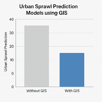
The rapid urbanization of the global population necessitates innovative approaches to urban planning, focusing on sustainability and efficiency. Geographic Information Systems (GIS) play a critical role in shaping smart cities by integrating spatial data to guide decision-making processes in urban management. This article explores the potential of GIS in urban planning, emphasizing its role in enhancing sustainability, optimizing resource allocation, and improving overall quality of life in cities. The paper presents several applications of GIS in urban contexts, from traffic management to environmental monitoring, and discusses the future of GIS in creating resilient, smart, and sustainable cities. Through the analysis of case studies and current advancements in spatial data technologies, the article highlights how GIS tools can facilitate smarter, more sustainable urban environments.
Downloads
Published
Issue
Section
License

This work is licensed under a Creative Commons Attribution-NonCommercial-NoDerivatives 4.0 International License.
All articles published in the Multidisciplinary Research in Computing Information Systems are licensed under an open-access model. Authors retain full copyright and grant the journal the right of first publication. The content can be freely accessed, distributed, and reused for non-commercial purposes, provided proper citation is given to the original work.