HARNESSING GEOSPATIAL INFORMATION SYSTEMS (GIS) FOR CLIMATE CHANGE MITIGATION
Keywords:
Geospatial Information Systems (GIS), Climate Change Mitigation, Environmental Monitoring, Sustainable DevelopmentAbstract
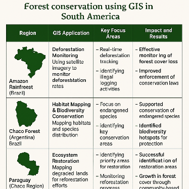
Geospatial Information Systems (GIS) have emerged as a transformative tool for addressing various environmental challenges, particularly climate change. This paper explores the pivotal role of GIS in climate change mitigation, focusing on its applications for environmental monitoring, risk assessment, and decision-making. GIS allows for the integration and analysis of spatial data, providing insights into climate patterns, vulnerability assessments, and the effectiveness of mitigation strategies. By examining global case studies and technological advancements, this paper highlights the potential of GIS in supporting sustainable environmental practices, including the development of climate-resilient infrastructure, renewable energy deployment, and land-use planning. The paper also discusses the challenges and opportunities for implementing GIS in climate change mitigation in developing countries, with a special focus on Pakistan’s approach to utilizing GIS technologies for environmental management and climate action.
Downloads
Published
Issue
Section
License
All articles published in the Multidisciplinary Research in Computing Information Systems are licensed under an open-access model. Authors retain full copyright and grant the journal the right of first publication. The content can be freely accessed, distributed, and reused for non-commercial purposes, provided proper citation is given to the original work.